Research Highlights
"Drone, Set the Reference for Us"… From Balloons to Basketballs, Capturing Every Motion Under the Sky in 3D
- Mechanical Engineering
- Date2026.11.17
- Views35
[POSTECH Professor Jin-Tae Kim's team develops an outdoor 3D tracking technology that uses a drone's flight path as a "moving ruler"]
The secret behind the lifelike movements of the characters in the film "Avatar" was motion capture, a technology that records movement in three dimensions by attaching markers to actors' bodies and filming them with multiple cameras inside a studio. However, bringing such precise measurement into wide outdoor spaces such as sports fields has never been easy. A Korean research team has now developed a technology that uses a flying drone as a "moving reference point" to precisely track the 3D motion of objects even across large outdoor spaces.
A research team led by Professor Jin-Tae Kim and master's student Jungyeon Kim of the Department of Mechanical Engineering at POSTECH has developed DAM3T1), a technology that precisely measures the 3D paths of objects across large outdoor spaces using a drone and multiple cameras. The study, a key interdisciplinary research outcome following the team's award of a U.S. Office of Naval Research (ONR) project, was published online in Science Advances.
To understand where fine particulate matter spreads on the wind, how low-flying aircraft move, or how groups of individuals travel together, we need technology that can accurately measure motion in three dimensions across wide outdoor spaces. The most common approach is to film the same object simultaneously with several cameras and calculate its 3D position. Just as we judge distance from the difference in position between our two eyes, the cameras must know exactly where they are and which direction they face to produce accurate 3D information. This process is called "calibration." Calibration becomes much harder as the space grows, so outdoors measurements have often required erecting giant grid boards or large structures on site, which has limited where measurements can be made and demanded considerable cost and manpower.
Taking a fresh approach, the team's Drone-Assisted Multicamera 3D Tracking (DAM3T) technology uses the path of a freely flying drone as the "reference" instead of setting up bulky equipment. When cameras placed at various locations film the flying drone simultaneously, a computer algorithm compares the drone's changing position in each view and calculates the cameras' positions and orientations on its own, with no manual alignment needed. By adding data from the drone's centimeter-level precision positioning system (RTK-GPS2)), the team made it possible to map the camera-measured motion directly onto real-world map coordinates of latitude, longitude, and altitude.
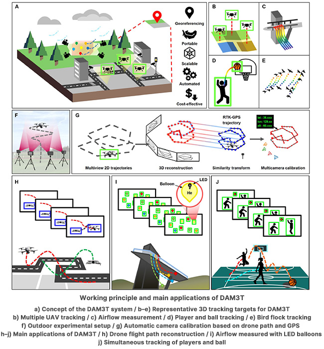
The technology also proved highly accurate. In a comparison with an indoor motion-capture system in a 6 m × 6 m × 3 m space (width × depth × height), the error was only about 2.3 cm (a normalized error of 1.15%). In outdoor experiments spanning tens of meters, the error was just 1.21%, with errors remaining below 2% both indoors and outdoors.
The team also demonstrated the technology's practical applicability. They tracked a multiple irregularly flying drones, visualized the flow of wind using LED-illuminated helium balloons, and, during an outdoor basketball game, separately reconstructed not only the players' movements across the court but also the 3D parabolic paths of the ball during passes and shots.
"This study shows that, freed from the spatial limits of the laboratory and the dependence on large calibration equipment, precise measurement is possible even across wide outdoor spaces by using a drone's flight path as the reference," said Professor Jin-Tae Kim. "In connection with the recently awarded U.S. Office of Naval Research project on next-generation aerodynamic surfaces and active flow control, we plan to apply this technology broadly to industrial and defense settings where precise measurement has been difficult, including atmospheric flow monitoring, precision tracking of unmanned aerial vehicles, autonomous control of multiple drones, and sports game analysis."
This research was supported by the Early Career Research Program of the National Research Foundation of Korea (NRF), funded by the Ministry of Science and ICT; a project of the NRF funded by the Ministry of Science and ICT and the Ministry of Education; and the U.S. Office of Naval Research (ONR).
▶️ DOI: https://doi.org/10.1126/sciadv.aeh8352
1. DAM3T (Drone-Assisted Multicamera 3D Tracking): A technology that uses a drone's flight path as an optical calibration reference to calibrate multiple cameras and track the 3D motion of objects across large outdoor spaces.
2. RTK-GPS (Real-Time Kinematic GPS): A real-time kinematic (RTK) positioning technique that compares satellite navigation signals received by a ground reference station and a moving receiver, correcting errors in real time to obtain centimeter-level position information far more precise than standard GPS. In this study, it was used to link the drone's precise position to real-world geographic coordinates.
Researcher
-

Kim Jin Tae Assistant Professor
Dept. of Mechanical Eng.
View Profile -

Jungyeon Kim
Master